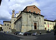
Città di Castello
Comune in Umbria, ItalyCittà di Castello ; "Castle Town") is a city and comune in the province of Perugia, in the northern part of Umbria. It is situated on a slope of the Apennines, on the flood plain along the upper part of the river Tiber. The city is 56 km (35 mi) north of Perugia and 104 km (65 mi) south of Cesena on the motorway SS 3 bis. It is connected by the SS 73 with Arezzo and the A1 highway, situated 38 km (23 mi) west. The comune of Città di Castello has an exclave named Monte Ruperto within Marche.
Read article


.svg)


Top Questions
AI generatedMore questions
Nearby Places
Roman Catholic Diocese of Città di Castello
Roman Catholic diocese in Italy
Badiali
Frazione in Umbria, Italy
Lerchi
Frazione in Umbria, Italy
Santa Lucia, Città di Castello
Frazione in Umbria, Italy
Titta, Città di Castello
Frazione in Umbria, Italy

Pinacoteca Comunale, Città di Castello
Art museum in Umbria, Italy
Sanctuary of the Madonna di Belvedere, Città di Castello
Church and Monastery of the Zoccolanti, Città di Castello